For over five decades, the families of Bhumlu Rural Municipality in Kavrepalanchok lived in quiet anxiety.
They tilled fields soaked with the sweat of generations and lived in homes handed down from their ancestors, yet legally, the land beneath their feet was not theirs.
In Ward No. 7 and Ward No. 8, nearly 1,100 families carried a constant fear: “What if one day someone says this land isn’t ours?” That fear hung over their lives, silently robbing them of peace and stability.
That fear ended on the morning of August 19, 2025 (Bhadra 3, 2082 B.S.). At the Bhumlu Rural Municipality office, a long-awaited dream finally became reality. Families who had been labeled “landless” for decades received their land ownership certificates, or Lalpurja, for the very first time.
It was not just a piece of paper—it was recognition, justice, and liberation all rolled into one. For these families, the ownership certificates symbolized freedom from the anxiety that had defined their lives for half a century.
On that day, 381 families officially became owners of the land they had nurtured for generations.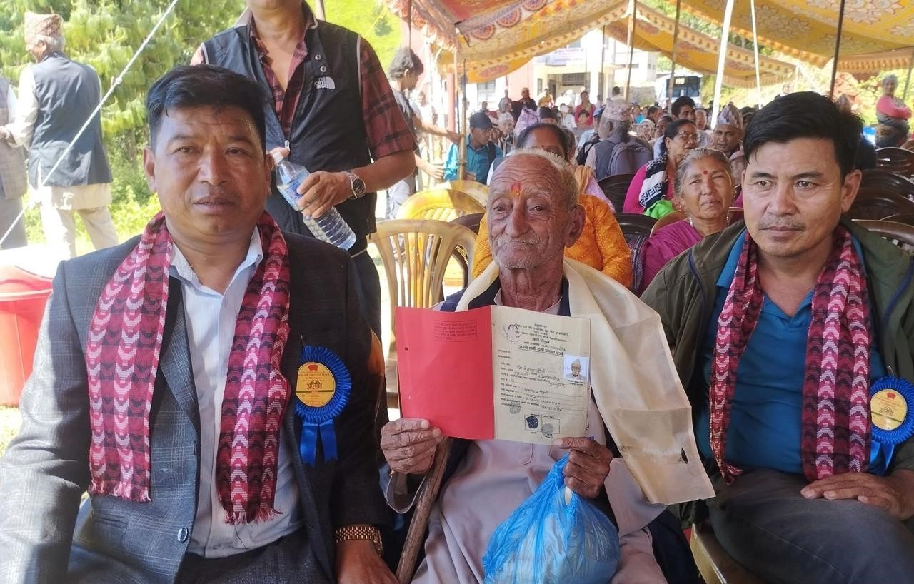
This historic achievement was not the result of a single act, but of persistent community effort, political will, and expert facilitation by the spider group. It was made possible through the transformation of a long-standing boundary conflict between two wards,
The road to this moment, however, had been long and painful. When Pipaltar functioned as a single Village Development Committee (VDC), cultivable lands known as “Tar” were farmed without conflict. But after the division of Pipaltar into separate VDCs, both Bhumlutar and Phalante laid claim to the fertile land. What began as a boundary disagreement escalated into a conflict that spread across the entire village.
Surveys in 1976 (2032 B.S.), sparked clashes over land boundaries and usage rights among villagers, leaving several injured. Communication between the two communities' ground to a halt for months. For nearly seven to eight months, residents of Phalante were forced to travel via the long and indirect route through Timal.
The survey team returned without completing its work.
The conflict did not remain confined to land alone. Both sides began asserting claims over water sources, grazing areas, and forest resources used for fodder and firewood.
Multiple committees and survey teams tried to resolve the conflict over the decades, but none succeeded. In the absence of land ownership certificates, villagers endured severe hardship. Lacking legal proof of ownership, they were deprived of the benefits and services that could otherwise have been accessed through the land.
In 1979 (2035 B.S.), a land survey team once again arrived in the village, but due to the ongoing conflict, the survey could not be carried out that time either.
An eleven-member committee was formed at the local level with the objective of facilitating land registration. Under the leadership of this committee, a delegation visited the Ministry of Land Reform. After reviewing the prevailing laws, the Ministry directed that land ownership certificates be issued accordingly.
Fourteen months later, a survey team arrived in accordance with the Ministry’s order. However, residents of Phalante again filed an application at the Land Revenue Office, arguing that land ownership certificates could not be distributed without first resolving the boundary conflict.
Repeated discussions were held at the District Survey Office and the Land Revenue Office to address the boundary issue, but the problem remained unresolved.
With the advent of federalism, new hope emerged in Bhumlu. Instead of repeating old administrative approaches, the rural municipality chose to address the problem at its roots and seek a solution through dialogue. To this end, the rural municipality formally entrusted the NRCTC-N with the responsibility of facilitating the process.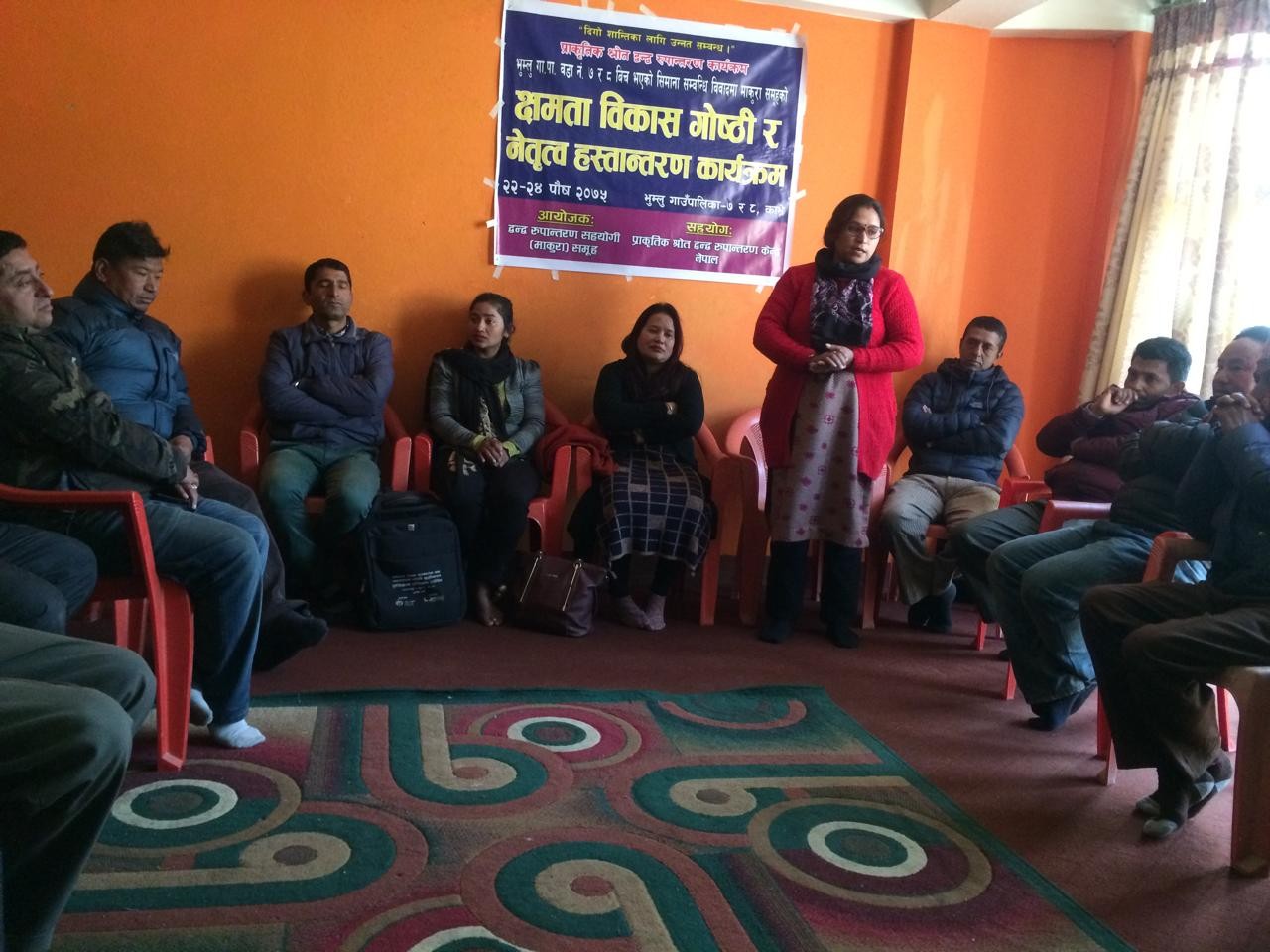
The Center initiated the conflict transformation process on November 2, 2018 (16 Kartik 2075 B.S.), giving momentum to a community-led effort to find a sustainable solution.
The NRCTC implemented the Spider Web process for conflict transformation. Procedurally, preparation meetings were held to lay the groundwork for transformation, and a conflict mapping was conducted. A “Spider Group” was formed by bringing together representatives from all parties involved in the Conflict.
Eleven facilitators, drawn from the community, who deeply understood local suffering and were sensitive to the perspectives and emotions of all sides, were engaged as members of the Spider Group.
They were provided with training and capacity-building opportunities to master conflict transformation. Emulating the meticulous way a spider builds its web, the facilitators engaged the community in homes and local gathering spots (Chautaris) and open pastures—to bridge the gaps left by decades of pain and bitterness. Despite the prevailing atmosphere of stress and discord, they remained steadfast in maintaining the flow of communication.
After seven months of procedural facilitation and 36 rounds of discussion, consensus was reached. On May 14, 2019 (Baisakh 31, 2076 B.S.), a historic eight-point agreement was signed, formally transforming the boundary conflict and setting the stage for land certification.
The agreement addressed boundaries, house locations, land measurement, installation of boundary pillars, access to grazing land, and use of natural resources.
With this community consensus in hand, government processes resumed smoothly, enabling survey teams to carry out their work unhindered.
Former chairperson of the rural municipality, Guman Dhwaj Kunwar, stated that the NRCTC–Nepal and the Spider groups selected from both wards played a crucial role in facilitating dialogue between communities and building consensus for conflict transformation. “It is only after the local government and relevant agencies supported the agreement reached with everyone’s participation that the land ownership certificates have now been handed over,” he remarked.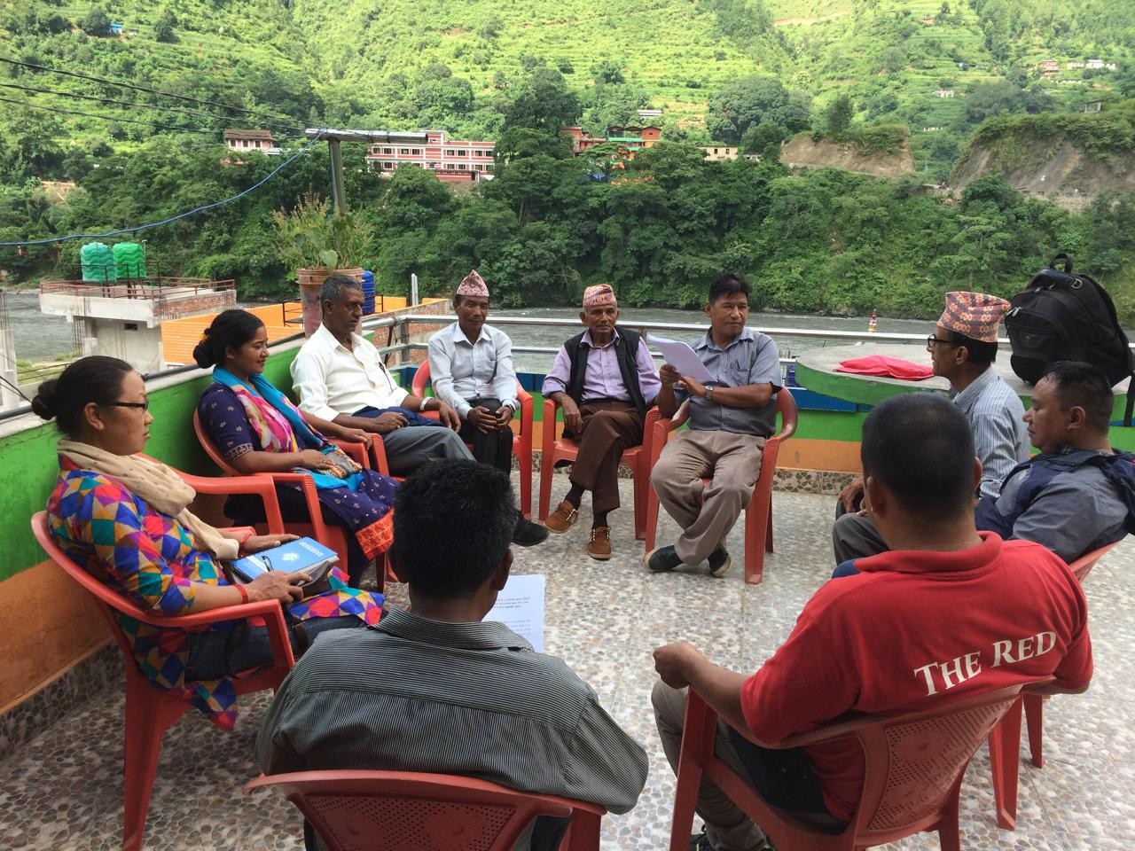
Motilal Tamang, chairperson of Ward No. 8, added, “The role of the spider group is commendable. They facilitated step-by-step discussions between the parties involved in the conflict and helped them reach a written agreement, which made it easier for the surveying team to work without obstruction. In the past, the surveying team would come, but when conflicts flared up within the community, work could not progress. After the spider group ensured a written agreement, the surveying team was able to carry out their work smoothly. Now, land ownership certificates are being issued rapidly.”
Rameshraj Kharel, chairperson of Ward No. 7, also praised the Makura initiative, saying, “the organization worked in coordination with the community and local government, following a win-win approach. Spider showed the way, we all followed, and this success was achieved. Otherwise, the land certificate distribution would not have been possible so quickly.”
In the first phase, 177 families in Ward 7 and 204 families in Ward 8 received their land certificates (Lalpurja). The remaining families are in the final stages of documentation.
For residents like Toran Bahadur Kshetri, it was an emotional milestone. “I never thought this day would come. I am grateful to everyone,” he said, holding the document that turned decades of uncertainty into security.
Bhumlu’s victory is more than a legal triumph; it is a blueprint for the rest of Nepal. It proves that even the most "impossible" knots can be untied through dialogue, patience, and community-led leadership. The five-decade-long conflict had tested their patience, coexistence, and faith in institutions. Today, Bhumlu moves forward as a united village, its people finally free from the shadow of fear and uncertainty. Their land, their home, and their peace—at last, truly theirs. Bhumlu is now moving forward not defined by conflicts, but towards peace, harmony, and sustainable development.